Dr Thomas Li – Spatial And Image Learning group.
Dr. Heyang (Thomas) Li is the Director of the Spatial and Image Learning (SAIL) Group. His research spans AI, spatial analytics, and computer vision, with applications in transport, healthcare, and infrastructure. He has led projects funded by Waka Kotahi, Christchurch City Council, and Stats NZ, including city-wide pavement monitoring and integrated screening tools for cardiovascular and eye health in general practice.
Dr. Li holds two U.S. patents in 3D imaging and has authored numerous publications in machine learning and image processing. As Director of SAIL, he supervises PhD and Master’s students, and promotes open-access, interdisciplinary research. He serves on the NZ AI Researcher Council, co-leads the Canterbury Biomedical Imaging Network, and frequently presents at international conferences.
Completed Projects
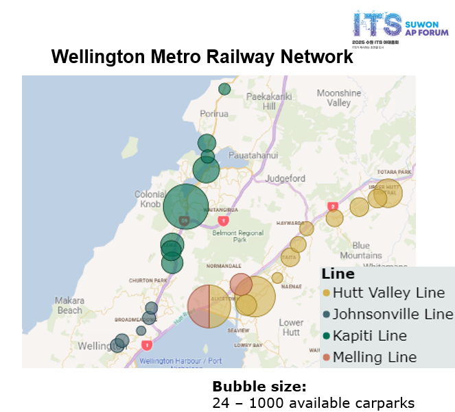
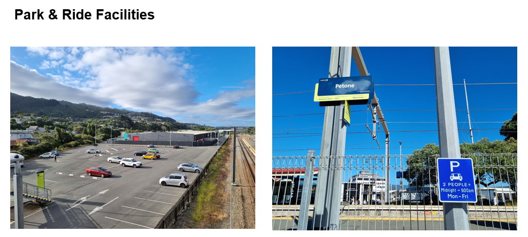
Enhancing public transport system efficiency with carpooling facilities as a first- and last-mile solution, a cost-neutral approach
Seamless connectivity between public transport networks and residential or workplace areas is crucial for encouraging public transport usage, thereby reducing traffic congestion and carbon emissions. We propose an innovative, cost-neutral parking model that combines free carpooling facilities and paid single-occupancy parking at strain stations, as a solution to the public transport connectivity challenge. It is designed to promote shared rides to train stations and regular train commutes. The additional revenue from paid parking and increased train ridership, forecasted at $11.58 million in the first two years of implementation, supports a self-sustaining cycle of service enhancements and commuter growth. This research provides a detailed assessment of cost and time efficiency for the proposed mobility solution, and an optimisation strategy to reinvest the additional revenue towards increasing service frequency during peak commuting hours. Lastly, environmental and health benefits, alongside potential reduction in road accidents and maintenance costs, will be briefly assessed to present a more comprehensive picture of the potential impact of our mobility solution.
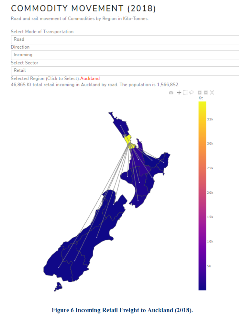
Evaluating the opportunity to engineer transition to a low carbon freight transport system in New Zealand
The Data Gathering report described a set of relevant open sources and commercial sensitive freight data in New Zealand. Upon careful evaluation of these data resources, this report briefly introduces a set of suitable modelling approaches. The model structure delineates requirements for data structures, functional forms, zoning framework, and calibration methods. The report also elaborates on the construction of the final data structure, and the relational data model. The raw data went through a data wrangling process that contemplates identifying issues (i.e., missing or incomplete values), data cleaning, definition of consistent temporal and spatial scales across all datasets and data consolidation in an online repository. Moreover, the process contemplates further data transformations that comply with structural requirements from the transport modelling counterpart.
The report also presents a description of geo-processing tasks applied to:
* Develop a zoning framework supported by boundaries represented through polygon features,
* Derive representative locations for zone origins and destinations,
* Build a virtual transport network and assign cost attributes,
Use thematic land-cover areas (polygons), demographic and economic data to deliver production and attraction attributes for every zone, and,
* Filter the traffic count data and allocate the heavy traffic data across the network links.
Finally, this document reviews data considerations for estimating rail and coastal shipping transport activity between each district.
Automated Footpath Distress Detection: From Data Collection to Implementation and RAMM Integration
This report presents an end-to-end automated footpath distress detection system, integrating hardware design, data collection, machine learning, and database integration for scalable infrastructure assessment. The project successfully developed a data collection system using GoPro cameras mounted on a mobility scooter, capturing over 240,000 images across 235 kilometres of footpaths, annotated for pavement distress types and severity levels. Using a hybrid model, the system achieved a robust ~80% accuracy in detecting diverse pavement defects. The project also developed tools for seamless output integration into the Road Assessment and Maintenance Management (RAMM) database, enabling precise, actionable maintenance planning. This scalable approach demonstrates a practical path from data acquisition to urban infrastructure management, with commercial viability and potential for widespread adoption.


Join 900+ subscribers
Stay in the loop with everything you need to know.